
Level of Significance
- File
- Local
- Regional
- State
- National
Age (approx)
250yrsTrees
1Diameter
1mHeight - 12m


Details
- Remnant (Scientific)
- Outstanding species (Scientific)
- Landscape (Social)
- Landmark (Social)
- Contemporary association (Social)
- Event (Historic)
- Person/Group/Institution (Historic)
- Attractive (Aesthetic)
Statement of Significance
The tree an outstanding example of its species and is remnant native vegetation. It makes a significant contribution to the landscape. The tree is an important landmark which marks the place where Camp LXV was set up by Burke and Wills’ party. It has contemporary association with the community and has become an important tourist attraction in the area, with over 35,000 tourists visiting the site each year. It is associated with Burke and Wills and their first successful south-north crossing of Australia opening up the country to pastoralism. It is a wonderful looking tree.
History
In 1860, the Victorian government sponsored an expedition to make the first south-north crossing of Australia to the Gulf of Carpentaria, a distance of 3,250 kilometres. Robert O’Hara Burke and William John Wills led the expedition from Melbourne and reached Cooper Creek by December 1860. Burke and Wills travelled north with Grey and King while four men remained. The stockade depot party left only hours before the return of Burke and Wills on 21 April 1861 after carving instructions into the tree to dig for provisions. Only John King was found alive by a search party in September 1861. The blazes on the ‘Dig Tree’ remain as a memorial to Burke and Wills’ expedition and a symbol of the bravery and hardships endured by Australia’s early explorers. The tree was originally called ‘William Brah’s Tree’ in 1911 (after one of the members of the expedition who remained at the depot before returning to Melbourne and who carved messages in the tree. In 1928 it was referred to by the Geographical Society of South Australia as ‘The Depot Tree’ but Frank Clune’s book ‘Dig’ of 1937 has been credited with current name of ‘The Dig Tree’. The tree remains one of Australia’s national icons. The land surrounding the tree is under the trusteeship of the Royal Historical Society of Queensland. The Register of the National Estate states, ‘The Dig Tree is a spreading Coolabah (Eucalyptus microtheca) growing by Cooper Creek, 6 km from the Nappa Merrie homestead. It is in a reserve owned by the Queensland Historical Society within the Nappa Merrie property owned by Stanbroke Pastoral Company. The tree has a blaze carved by the Depôt team waiting for Burke and Wills to return from the Gulf of Carpentaria in 1861. Although the Dig tree is identified the site of the Depot camp, the stockade that was built is not known. Near the tree is another Coolabah with a face in the likeness of Robert O' Hara Burke carved out of blaze. This tree is also important and within the Reserve area. The tree has been treated for pests and visited by Dr Ross Wiley, a tree surgeon with the Queensland Department of Primary Industry. Board walks have been established around the base of the tree to prevent soil compaction. It is expected that one limb will drop soon. The blaze is gradually being overgrown. Approximately 35,000 tourists visit the site each year.’
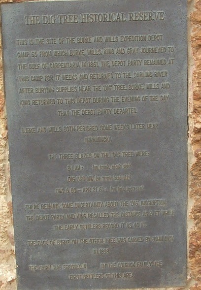
A plaque at the site states, 'The Dig Tree Historical Reserve. This is the site of the Burke and Wills expedition Depot Camp 65 from which Burke, Wills, King and Gray journeyed to the Gulf of Carpentaria in 1851. The depot party remained at this camp of 17 weeks and returned to the Darling River after burying supplies near the 'Dig' Tree. Burke, Wills and King returned to this depot during the evening of the day that the depot party departed. Burke and Wills perished some weeks later near Innamincka. The three blazes on the Dig Tree were
B LXV Trunk, creek side
Dig 3FT NW Trunk, land side
Dec 6 60 April 21 61 Limb upstream
There remains some uncertainty about the 'Dig' inscription. The Burke party recalled the distance as 3 ft while the early settlers recalled it as 40 ft. The face of Burke on the other tree was carved by John Dick in 1898. The Cairn was erected in 1937 by the Conrick family the first settlers in the area.'
Location
The tree is located on the northern Bank of Cooper Creek, at Bulla Bulla Crossing, six kilometres from the Nappa Merrie homestead.